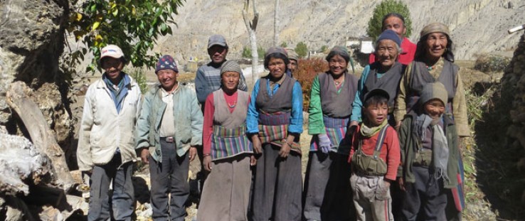
 Villagers of Dhey
Brownwyn Llwellyn
 Villagers of Dhey
Brownwyn Llwellyn
Nepal’s Solu Khumbu region is best known for the mighty mountain that sits at its northern end: Mount Everest, or Sagarmatha (“Mother of the Universe”) as it is known to Nepalis. The Khumbu region has developed rapidly in the past several decades, largely because of the increasing numbers of tourists who come to trek between the mountain villages, some reaching the Everest base camp. The approximately 5,000 local Sherpa people who live in the region have benefited from this new economy, and migrants from other parts of Nepal have arrived to work as porters or staff in the many tourist lodges.
But climate change is affecting the high mountain valleys of the Himalaya and the glaciers that rise above them, posing a threat to local development gains. A decade ago, says Ang Chiring Sherpa, a lodge owner in the village of Phereche, the mountain pass he could see from his lodge “was white. It was really beautiful. Now I look at the same place and it’s all black.”
As many as 1.3 billion people live downstream from the Himalayan glaciers, covering countries as far away as China, India, Pakistan, Bangladesh, Burma, Thailand and Vietnam. As the glaciers melt under rising temperatures, flows of water temporarily increase. But over time, the shrinking glaciers mean that water for agriculture and hydropower will become increasingly scarce.
“People say glaciers are the canary in the coal mine when it comes to climate change impacts,” says Daene McKinney, a professor of environmental and water resources engineering at the University of Texas at Austin. “These changes are today, not just in the future.”
The changes are also presenting high mountain communities with new risks and increasing danger. As the glaciers melt, hundreds of new glacial lakes are formed that are held back by walls of unstable soil, ice and rock. At least 10 of these lakes have already burst in Nepal in the past 40 years, killing people and destroying farmland, homes, roads and bridges.
Scientists and local residents alike are concerned that Imja Lake in the Khumbu region may soon join the list of such glacial lake outburst floods. Recent studies carried out by scientists working with the USAID-supported High Mountain Glacial Watershed Program, which supports efforts to build climate resilience in the world’s alpine regions, show that Imja Lake is much deeper and larger than previously thought.
Imja Lake didn’t exist before 1960; today it is 380 feet deep and 1.25 miles long. Due to increased glacial melt, it is expected to expand an additional half mile in the next five or six years. Local residents share the scientists’ concern. “If Imja Lake bursts, it will result in a huge accident and human loss,” said Chembang Thume Sherpa, a community leader in the village of Phakding.
Mountain Scientists Converge
In 2011, USAID and the National Science Foundation brought mountain scientists from around the world to Imja Lake to look at what could be done. For the first time, local communities were brought into the discussion. Previously, “communities had no voice in research—no access to what was being learned. Scientists had been going there for 30 years and not talking to them,” said Alton Byers, director of science and exploration at The Mountain Institute (TMI), the organization that is implementing this USAID project in partnership with the University of Texas at Austin.
Local residents expressed concern about the changes they have been seeing around the lake, and the increased risk of flooding. “If Imja Lake floods, that will definitely affect tourism here—but it will also affect the entire region, and people from the mountains to the lowlands. That’s why we are ready to support efforts to reduce this risk however we can,” said Ang Nima Sherpa, head of the Khumbu Alpine Conservation Council.
One of the visiting scientists was Cesar Portocarrero, a Peruvian civil engineer who has worked for more than 30 years managing dangerous glacial lakes in the Andes. The communities in Nepal “know that rainfall patterns have changed, that temperatures have changed. They noticed that a long time ago, even before scientists started talking to them about climate change,” Portocarrero said.
“I went to Nepal and said: ‘I am here to share with you all that I have done.’ We have a lot in common. I identify with the Nepali people. There’s the Everest route, which attracts tourists. But there are other parts of the Himalaya in Nepal that are not tourist destinations, where people live like they do in Peru—dependent on agriculture, on the water from the glaciers.”
Portocarrero has returned to Nepal five times in the past year, with support from USAID. Now he is helping in the design of an engineering project, proposed by the United Nations Development Program (UNDP), to reduce the risks at Imja Lake.
“It’s Not Just Nepal”
Portocarrero and other USAID partners are working to ensure that the engineering project is based on updated lake measurements, and that it considers different kinds of approaches in order to find the most effective way to reduce the risk of sudden flooding. For example, they are currently weighing the benefits of lowering the lake by different amounts—a few meters or more—and adding a downstream dam as a flood retention structure.
USAID has funded research with ground-penetrating radar—a method to study the subsurface without drilling—to map out where the ice and bedrock are located. Lowering the lake will require making cuts to drain water; and scientists will need to know whether they are going to be cutting through rock, or through ice, which could crack and exacerbate the flooding risk.
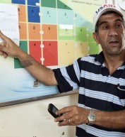
Meanwhile, USAID and its local partners are holding community workshops to make sure that Khumbu communities receive the research results, understand the risks they face, and are involved in the decisions about how to manage them.
“Local communities are very far from the information that they need about climate change, even though they will be most directly affected by its impacts. So it is really important to inform the people in these areas,” said Phurba Sherpa of TMI, who helped organize and run the workshops.
“We are very hopeful that this workshop will lead to positive action, so we don’t need to worry about a glacial lake outburst flood,” said Sona Yishi Sherpa, a lodge owner from the village of Dingboche who participated in one of the workshops.
By helping local communities plan ahead and take action to reduce the chance of a glacial lake outburst flood, USAID is building their climate resilience and also reducing the likelihood that emergency humanitarian assistance will be needed.
“The study in Nepal is not only important for Nepal,” Portocarrero noted.
Byers concurs: “Imja Lake is not the only lake growing at this rate. It’s not just Nepal—it’s Peru, Tajikistan, Pakistan, Bhutan. Therefore, it is even more important to develop a model for how to do the science, and how to work with local communities and decision makers.”

A New Dhey
By Bronwyn Llewellyn
It is harvest time in Upper Mustang, along the northern border of Nepal, and the vibrant pink of buckwheat surrounds most of the white-walled villages. However, riding into the village of Dhey, one is struck by brown, wilted grass and barren ground rather than lush fields.
In the southern Khumbu region, glacial melt is causing lakes to burst their boundaries in dangerous landslides. In Upper Mustang, glacial melt and changing rain patterns spark a different, but equally damaging effect: the recent loss of year-round access to water. In communities like Dhey, the only source of water after the monsoon rains pass is summer-melt water from the nearby glacier. Once that glacier is gone, there is no more water in the stream that provided dry season water for centuries.
Glaciers have always slowly melted in the summer, and snowpack helped recharge them in the winter. But throughout the Himalayas, climate change is making glaciers melt much more quickly than they did in the past. In a few places the extra water gets trapped in lakes, but in most of Nepal the villagers only notice a slight increase for a few years before the water suddenly stops coming at all.
The impact of this loss on Dhey, a close-knit community of 24 households, is so profound that the entire village has decided to move away from ancestral homes and land to resettle in new areas. This terrible loss raises land disputes and reduces the extended family’s financial foundations. “People come and tell us we have such a beautiful village, why leave? But they do not live here. We cannot survive here,” said village leader Mukhiya Pasang Gurung.
USAID/Nepal is working to help Dhey and other vulnerable communities across Nepal identify new technologies to better manage, store and use water, understand the effects that climate change will have on them, and promote their rights to sustainably access their resources. These techniques can be used by the new Dhey and other villages affected by global climate change for improved resilience that will last for generations to come.




Comment
Make a general inquiry or suggest an improvement.