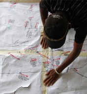
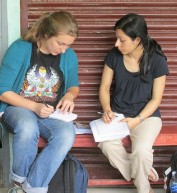
 Farmers write notes during a Climate Field School session in barangay Dela Fe in Buhi, Camarines Sur.
Annalyn I. Olaño
 Farmers write notes during a Climate Field School session in barangay Dela Fe in Buhi, Camarines Sur.
Annalyn I. Olaño
Narciso Ballester is a farmer in Nabua, a low-lying municipality in the Philippines’ Bicol region. Bicol gets pummeled by about six out of the 20 typhoons that pass through the country each year. Rice farms submerged in flood waters or harvest-ready crops flattened by strong winds are every farmer’s dread.
Increasingly, farmers face a new problem: dry spells and El Niño, which reduce water supplies for irrigating rice paddies. From 2007 to 2011, rice farming in Bicol incurred $122 million worth of damage due to typhoons, floods and droughts, roughly 8.4 percent of the $1.5 billion total damages incurred in the country.
These cyclical weather events severely impact farmers, forcing them to buy rice and other crops to feed their families instead of consuming their own produce. With lost income, some borrow money, sell their animals or furniture, or mortgage their lands just to have enough cash for basic needs.
These hardships once could have been avoided, but climate change has robbed the farmers of their ability to predict the weather, a skill passed down through the generations and sharpened by years of experience.
“Before, we predicted the weather and knew when to plant,” Ballester recalled. “But these days, the weather is unpredictable. Now the dry season can bring continuous rain while the hot season is too wet. The changing climate affects us (farmers) because our rice fields flood in heavy rain. When it’s too hot, we don’t have enough water for our fields.”
Tired of hit-or-miss predictions, Ballester joined 893 farmers from Nabua, Buhi and Polangui municipalities in 2013 for Climate Field School (CFS).
CFS is a classroom-based program from the Bicol Agri-Water Project (BAWP), a $1.5 million grant initiated by USAID in 2012 through the Development Grants Program. This five-year project is implemented in partnership with the University of the Philippines Los Baños Foundation Inc. and the Philippines Department of Agriculture.
CFS ran for two cropping seasons, or 48 weeks. Farmers gathered each morning in makeshift classrooms—village halls, chapels, public schools, farmers’ houses—eagerly listening and taking notes. Husbands and wives arrived in tandem, learning how climate change impacts rice production and how to improve harvests with different farming techniques. After class, they visited demonstration farms, observing rice varieties and growth stages, and applying climate-adapted technologies.
“We learned to adapt to unpredictable weather conditions to increase our rice and income,” said Ballester. In this year’s dry season, Ballester harvested 120 sacks of rice—a third more than his usual harvest of 85 sacks before the start of CFS. This boosted his income from $430 to $636 for this cropping season. Most CFS-trained farmers in all three municipalities experienced increased harvests, officials with BAWP said.
BAWP results are important for the region. According to the Philippines Department of Agriculture, Bicol ranked sixth among the country’s 16 regions and contributed over 6 percent to the country’s rice production last year. The region’s increased rice production can contribute to achieving the government’s goal of rice self-sufficiency. For farmers, adapting to climate change can help them avoid future losses, and enable them to invest more in farming or other livelihoods and support their children’s education.
In August 2015, farmers began receiving advisories from BAWP partners on best practices attuned to the three-month weather outlook, developed by the project in collaboration with Columbia University’s International Research Institute for Climate and Society.
All 893 farmers graduated from CFS and still receive coaching from the USAID project. Their municipalities aim to adopt the CFS, allocate their own resources and run the program independently.
“We are lucky to participate in the Climate Field School. Farmers can now increase their yield, income and products, uplifting lives in Nabua’s community,” said Mayor Delia C. Simbulan, whose municipality was the first to approve an ordinance adopting the CFS.
Seeing the project’s benefits, the Regional Development Council 5, Bicol’s highest planning agency, endorsed additional funding from other donors to bring BAWP’s approach to the four remaining provinces of Bicol. And, outside of Bicol, USAID is helping increase climate resilience of vulnerable farming communities in Isabela and Agusan del Sur provinces.
Agnes Rola, project director, and Kae B. Perlas, project assistant, of the Bicol Agri-Water Project contributed to this article as well as Elena Delos Santos, technical director for operations and extension, Philippines Department of Agriculture-Regional Field Office 5.
In the Aftermath of Typhoon Haiyan
On average, 20 typhoons hit the Philippines each year, and these storms are showing signs of becoming more intense and less predictable. In 2013, Haiyan was the most powerful typhoon ever to make landfall, slamming ashore with 195 mph winds, killing 6,300 people and displacing 4.1 million—more than the population of Oklahoma. Global disaster relief reached $800 million, of which approximately $143 million came from the United States.
Two years later, Filipinos are continuing to rebuild homes and livelihoods. USAID is supporting both the government and local communities to build back better. Efforts include adding weather stations and using climate data and technology to improve early warning and emergency response systems. The efforts also include helping determine where to rebuild water pipelines and power generation so they are resilient to storms. In some communities, USAID is working to restore forests and mangroves to protect against landslides and storm surges.
Climate-smart information and planning is critical to building resilience in the Philippines. With USAID support, the Philippine Atmospheric, Geophysical and Astronomical Services Administration is providing tailored weather and hazard risk maps to local governments so they can integrate this information into planning. In the meantime, the Philippine Department of Science and Technology’s Project NOAH is using supercomputers to generate real-time forecasts and flood modeling, including maps layered with historical storm data showing which neighborhoods are most likely to flood. NOAH also provides online and mobile storm surge data to help people find safe locations in a crisis.





Comment
Make a general inquiry or suggest an improvement.