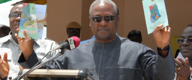
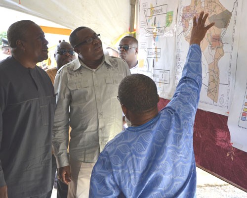
 Ghanaian Vice President John Dramani Mahama is briefed on street naming and numbering projects, April 28, 2012.
credit: Henry Boachi, MSI/USAID
 Ghanaian Vice President John Dramani Mahama is briefed on street naming and numbering projects, April 28, 2012.
credit: Henry Boachi, MSI/USAID
Ask for directions in Ghana and you will likely hear something like this: “When you get to the next junction, turn right, look out for the coconut tree, behind which you will find a yellow kiosk. Ask whoever you see for Auntie Akua’s house. Next to Auntie Akua’s house is the house you are looking for.”
In 2010, Ghana’s urban population exceeded 50 percent. Ten years earlier, 44 percent of Ghanaians lived in cities, with the remainder residing in rural communities. As the country of over 24 million rapidly urbanizes, many communities still lack street names and house numbers, and rely instead on informal directions and local landmarks. Mail delivery is restricted to P.O. boxes, and access by emergency services—including ambulances, firefighters and police—is limited. It is also a barrier to efficient commerce and has a negative impact on small business and the country’s economic growth as a whole.
Businesses, including financial institutions and telecom service providers, currently have a difficult time tracking their debtors. “Sometimes, it takes weeks, and even months, to locate a person my company loaned money to, if we are lucky. We have to resort to asking, for example, ‘Do you know Auntie Akosua?’ and more often than not the answer is ‘no,’” said Wilfred Ashong, a microfinance business owner.
However, this is changing with a new Ghanaian initiative supported by USAID. In April, Ghanaian Vice President John Dramani Mahama launched the National Policy Document and Operational Guidelines on Street Naming and Property Addressing System. These policy documents provide local metropolitan, municipal and district assemblies (MMDAs) with guidance to develop land-use plans for their cities as well as to name existing thoroughfares.
In December 2011, USAID signed memorandums of understanding with five districts and has since provided them with state-of-the-art computer equipment, satellite imagery and training in geographical information system (GIS) mapping. Through the use of the GIS tools and mapping software, planners can now digitally assign unique identification numbers and issue permits for specific parcels of land, making it easy to track who owns which parcel, and for what purpose. As a result, it will be easier to maintain a more reliable database of all physical structures, including residencies, recreational facilities and businesses.
In parallel, the district assemblies formed street addressing teams and have begun to generate digital maps of their districts. Once the mapping and street naming is complete, USAID will fund street signs to be customized and installed by district assemblies. The street names will be generated by consulting with traditional chiefs and elders of the various communities who are abreast of an area’s history and culture.
The new street names and property identification will have another economic benefit beyond helping customers and business connect—the addresses will be digitally integrated into a tax-collection database with future taxes slated to help sustain district development and growth. USAID, in fact, predicts a 30-percent increase in tax revenues once cities begin using GIS databases to assess property taxes. The effort will save on property valuation as it will no longer be necessary to produce new base maps.
“The street naming exercise will now provide the Internal Revenue Service and other revenue-generating organizations the opportunity to access all businesses and properties that are taxable,” said Mahama. This kind of increase in local revenue generation will enable Ghana to achieve its goal of aid independence.
A Boon to Local Government
Improved spatial data will be an important boon to local governments. Currently, most MMDAs in Ghana do not have accurate information on property ownership and are unable to collect all property taxes. The central government funds each decentralized district budget from a common pot. These quarterly transfers are typically delayed, and even if received in full, in some cases will only cover 10 percent of development needs. As a result, a district’s ability to raise its own revenue is a key ingredient to improving the quality of life for its residents.
“We will have data about the types of businesses and residencies and their respective locations, following the street naming and property addressing. We will then be able to group residencies and businesses, and collect the appropriate revenues to build the schools and hospitals our people need,” said Enoch Appiah, district chief executive of Shama.
Many challenges remain to meet the vice president’s goal of implementing the guidelines throughout the 212 districts of the country. Conservative estimates based on USAID’s experience with five districts suggest that Ghana would need at least $30 million to implement the program nationwide. This estimate does not include the major cities, as cost may vary depending on size. The Ghanaian Government may have to solicit these funds from external sources. Another challenge: Ghanaians, like most people in the world, are not the most enthusiastic tax payers, and collection enforcement can be difficult.
While there are legitimate challenges to achieving nationwide street naming and property numbering, the Ghanaian Government remains optimistic that it will ultimately be an important driver of progress.
“Hopefully, when we are able to collect the right revenues following the street naming and property identification, it will help us to greatly speed up the development of this country,” said Mahama. n Peter Fricker is chief of party of USAID’s Local Governance and Decentralization Program in Ghana.
Peter Fricker is chief of party of USAID’s Local Governance and Decentralization Program in Ghana.




Comment
Make a general inquiry or suggest an improvement.